
Gracias por apoyar a este sitio ❤️
Haz una donación
Haz una donación
Mapa topográfico Tarn Hows
Haga clic en el mapa para ver la altitud.
Gracias por apoyar a este sitio ❤️
Haz una donación
Haz una donación
Acerca de este mapa
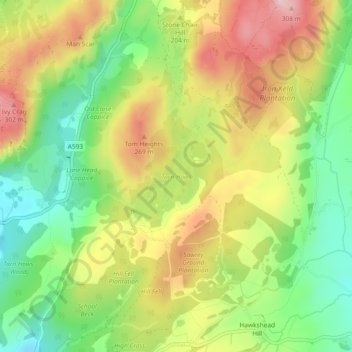
Nombre: Mapa topográfico Tarn Hows, altitud, relieve.
Altitud media: 187 m
Altitud mínima: 74 m
Altitud máxima: 315 m
Gracias por apoyar a este sitio ❤️
Haz una donación
Haz una donación
Otros mapas topográficos
Haga clic en un mapa para ver su topografía, su altitud y su relieve.
Old Man of Coniston
United Kingdom > England > Westmorland and Furness > Coniston
The first section rising steeply from Coniston is a metalled road, maintained partly to provide access to the quarry. This leads to a car park at an altitude of 740 ft (230 m), a popular starting point for climbs. Beyond here motor vehicles are prohibited, but the track continues to its summit at 2,000 ft (610…
Altitud media: 501 m
Gracias por apoyar a este sitio ❤️
Haz una donación
Haz una donación