
Haz una donación
Mapa topográfico Gogar
Haga clic en el mapa para ver la altitud.
Haz una donación
Acerca de este mapa
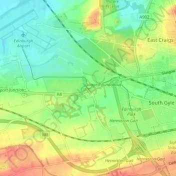
Nombre: Mapa topográfico Gogar, altitud, relieve.
Lugar: Gogar, City of Edinburgh, Scotland, EH12 9BR, United Kingdom (55.91802 -3.35328 55.95802 -3.31328)
Altitud media: 51 m
Altitud mínima: 25 m
Altitud máxima: 87 m
Haz una donación
Otros mapas topográficos
Haga clic en un mapa para ver su topografía, su altitud y su relieve.
Currie
United Kingdom > Scotland > City of Edinburgh
The period 1921-1951 brought great changes with the building of more council houses in Currie and private building along Lanark Road. Wider scale development began in the late 1950s and early 1960s with the construction of a private housing estate to the east of Curriehill Road. House builders began to promote…
Altitud media: 163 m
Haz una donación
Hermitage of Braid and Blackford Hill Local Nature Reserve
United Kingdom > Scotland > City of Edinburgh
Altitud media: 107 m
Haz una donación
Haz una donación
Haz una donación
Haz una donación
Haz una donación