
Mapa topográfico Ormiston
Mapa interactivo
Haga clic en el mapa para ver la altitud.
Acerca de este mapa
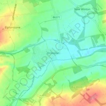
Nombre: Mapa topográfico Ormiston, altitud, relieve.
Lugar: Ormiston, East Lothian, Scotland, EH35 5HT, United Kingdom (55.89285 -2.95984 55.93285 -2.91984)
Altitud media: 102 m
Altitud mínima: 75 m
Altitud máxima: 159 m
Ormiston is a village in East Lothian, Scotland, near Tranent, Humbie, Pencaitland and Cranston, located on the north bank of the River Tyne at an elevation of about 276 feet (84 m).