
Mapa topográfico Cap La Ronde
Mapa interactivo
Haga clic en el mapa para ver la altitud.
Acerca de este mapa
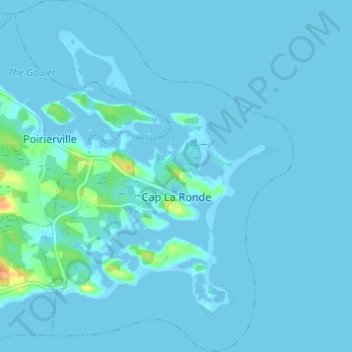
Nombre: Mapa topográfico Cap La Ronde, altitud, relieve.
Altitud media: 2 m
Altitud mínima: -5 m
Altitud máxima: 35 m
Otros mapas topográficos
Haga clic en un mapa para ver su topografía, su altitud y su relieve.
Battery Provincial Park
Canada > Nova Scotia > Municipality of the County of Richmond > St. Peter's
Battery Provincial Park, St. Peter's, Municipality of the County of Richmond, Richmond County, Nova Scotia, Canada
Altitud media: 9 m
Louisdale
Canada > Nova Scotia > Municipality of the County of Richmond
Louisdale, Municipality of the County of Richmond, Richmond County, Nova Scotia, B0E 1V0, Canada
Altitud media: 26 m
Potato Island
Canada > Nova Scotia > Municipality of the County of Richmond > Poirierville
Potato Island, Poirierville, Municipality of the County of Richmond, Richmond County, Nova Scotia, Canada
Altitud media: 4 m
Thorn Creek
Canada > Nova Scotia > Municipality of the County of Richmond > Glasgow Point
Thorn Creek, Glasgow Point, Municipality of the County of Richmond, Richmond County, Nova Scotia, Canada
Altitud media: 4 m
St. Peters Inlet
Canada > Nova Scotia > Municipality of the County of Richmond > Barra Head
St. Peters Inlet, Chapel Island 5, Barra Head, Municipality of the County of Richmond, Richmond County, Nova Scotia, Canada
Altitud media: 17 m
Berry Island
Canada > Nova Scotia > Municipality of the County of Richmond > Martinique
Berry Island, Martinique, Municipality of the County of Richmond, Richmond County, Nova Scotia, B0E 1V0, Canada
Altitud media: 41 m