
Haz una donación
Mapa topográfico Peterborough
Haga clic en el mapa para ver la altitud.
Haz una donación
Peterborough
The cathedral city of Ely is 24 miles (39 km) east-southeast across the Fens and the university city of Cambridge is 30 miles (48 km) to the southeast. The local topography is flat, and in places, the land lies below sea level.
Haz una donación
Acerca de este mapa
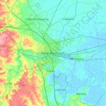
Nombre: Mapa topográfico Peterborough, altitud, relieve.
Altitud media: 17 m
Altitud mínima: -19 m
Altitud máxima: 92 m
Haz una donación
Otros mapas topográficos
Haga clic en un mapa para ver su topografía, su altitud y su relieve.
Cambridge
United Kingdom > England > Cambridgeshire
The city, like most of the UK, has a maritime climate highly influenced by the Gulf Stream. Located in the driest region of Britain, Cambridge's rainfall averages around 570 mm (22.44 in) per year, around half the national average, The driest recent year was in 2011 with 380.4 mm (14.98 in) of rain at the…
Altitud media: 18 m
Haz una donación
River Great Ouse or Ely Ouse
United Kingdom > England > Cambridgeshire > East Cambridgeshire > Soham > Stuntney
Altitud media: 4 m
Haz una donación
Haz una donación
Haz una donación
Ely
United Kingdom > England > Cambridgeshire
Ely is built on a 23-square-mile (60 km2) Kimmeridge Clay island which, at 85 feet (26 m), is the highest land in the Fens. It was due to this topography that Ely was not waterlogged like the surrounding Fenland, and was an island separated from the mainland. Major rivers including the Witham, Welland, Nene…
Altitud media: 4 m
Haz una donación
Haz una donación
Haz una donación
Hinchingbrooke Country Park
United Kingdom > England > Cambridgeshire > Huntingdonshire > Huntingdon > Brampton
Altitud media: 16 m
Haz una donación
Haz una donación
Haz una donación
Haz una donación
Haz una donación
Bluntisham
United Kingdom > England > Cambridgeshire > Huntingdonshire > Bluntisham
Altitud media: 12 m
Haz una donación
Haz una donación
Haz una donación
Haz una donación
Chittering
United Kingdom > England > Cambridgeshire > South Cambridgeshire > Waterbeach
Altitud media: 3 m
Haz una donación
Old Weston
United Kingdom > England > Cambridgeshire > Huntingdonshire > Old Weston
Altitud media: 65 m
Haz una donación
Great Staughton
United Kingdom > England > Cambridgeshire > Huntingdonshire > Great Staughton
Altitud media: 43 m
Haz una donación
Bassingbourn cum Kneesworth
United Kingdom > England > Cambridgeshire > South Cambridgeshire
Altitud media: 39 m
Haz una donación
Haz una donación
Holywell-cum-Needingworth
United Kingdom > England > Cambridgeshire > Huntingdonshire
Altitud media: 10 m
Hail Weston
United Kingdom > England > Cambridgeshire > Huntingdonshire > Hail Weston
Altitud media: 31 m
Haz una donación
Chippenham
United Kingdom > England > Cambridgeshire > East Cambridgeshire > Chippenham
Altitud media: 22 m
Haz una donación
Haz una donación
Haz una donación