
Haz una donación
Mapa topográfico Little Langdale
Haga clic en el mapa para ver la altitud.
Haz una donación
Little Langdale
Little Langdale Tarn is a natural tarn within a marshy area of the valley. The area around the tarn is managed by the National Trust and has no public access. It is typical Southern Cumbrian meso-oligotrophic tarn, whilst not at a particularly high altitude itself it has a mean catchment altitude of 520 metres (1,710 ft)
Haz una donación
Acerca de este mapa
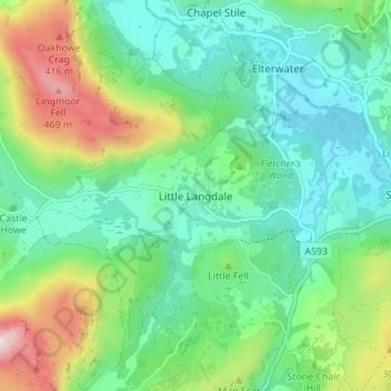
Nombre: Mapa topográfico Little Langdale, altitud, relieve.
Altitud media: 183 m
Altitud mínima: 49 m
Altitud máxima: 514 m
Haz una donación
Otros mapas topográficos
Haga clic en un mapa para ver su topografía, su altitud y su relieve.
Haz una donación
Mallerstang Edge
United Kingdom > England > Westmorland and Furness > Mallerstang
Altitud media: 489 m
Haz una donación
Haz una donación
Haz una donación
Howgill Fells
United Kingdom > England > Westmorland and Furness > Ravenstonedale
Altitud media: 303 m
Wharton Tarn
United Kingdom > England > Westmorland and Furness > Hawkshead > Hawkshead Hill
Altitud media: 173 m
Haz una donación
River Lune
United Kingdom > England > Westmorland and Furness
The river begins as a stream at Newbiggin, in the parish of Ravenstonedale, Cumbria, at St. Helen's Well (elevation of 238 metres (781 ft) above sea level) and some neighbouring springs. On the first two miles of its course, it is joined by four streams, two of them as short as itself, but two much longer.…
Altitud media: 220 m
Haz una donación
Haz una donación
Haz una donación
Haz una donación
Haz una donación
Haz una donación
Deepdale Beck
United Kingdom > England > Westmorland and Furness > South Lakeland > Dent
Altitud media: 280 m
Roudsea Wood
United Kingdom > England > Westmorland and Furness > South Lakeland > Haverthwaite
Altitud media: 7 m
Scout Scar
United Kingdom > England > Westmorland and Furness > Brigsteer
Scout Scar, also called Underbarrow Scar, is a hill in the English Lake District, west of Kendal, Cumbria and above the village of Underbarrow. It reaches 771 feet (235 m). Scout Scar is the subject of a chapter of Wainwright's book The Outlying Fells of Lakeland, but the summit he describes is a lower summit…
Altitud media: 130 m
Haz una donación
Haz una donación
Haz una donación
River Glenderamackin
United Kingdom > England > Westmorland and Furness > Threlkeld
Altitud media: 346 m
Haz una donación
Haz una donación
Three Dubs Tarn
United Kingdom > England > Westmorland and Furness > Bowness-on-Windermere
Altitud media: 156 m
Haz una donación
School Knott Tarn
United Kingdom > England > Westmorland and Furness > Windermere
Altitud media: 168 m
Haz una donación
Knipe Tarn
United Kingdom > England > Westmorland and Furness > Winster > Mitchelland
Altitud media: 131 m
Haz una donación
Haz una donación
Newton Tarn
United Kingdom > England > Westmorland and Furness > High Newton > Low Newton
Altitud media: 102 m
Brothers Water
United Kingdom > England > Westmorland and Furness > Patterdale > Hartsop
Altitud media: 298 m
Haz una donación
Haz una donación
Haz una donación
Haz una donación
Staveley-in-Cartmel
United Kingdom > England > Westmorland and Furness > Staveley-in-Cartmel
Altitud media: 110 m
Haz una donación