
Haz una donación
Mapa topográfico Duck River Suck
Haga clic en el mapa para ver la altitud.
Haz una donación
Acerca de este mapa
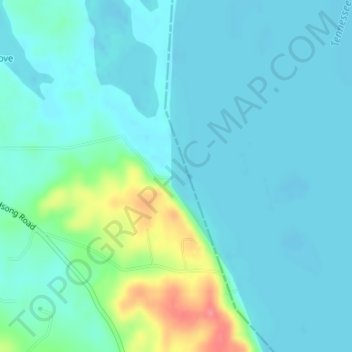
Nombre: Mapa topográfico Duck River Suck, altitud, relieve.
Lugar: Duck River Suck, Benton County, Tennessee, United States (35.96223 -88.02425 35.96233 -88.02415)
Altitud media: 120 m
Altitud mínima: 106 m
Altitud máxima: 182 m
Haz una donación
Otros mapas topográficos
Haga clic en un mapa para ver su topografía, su altitud y su relieve.
Haz una donación
West Tennessee
West Tennessee is located almost entirely within the Mississippi Embayment, part of the Gulf Coastal Plain. Because of this, the terrain is flatter than the eastern parts of the state. Areas along the Mississippi River are located within the Mississippi Alluvial Plain, which is primarily a floodplain with many…
Altitud media: 127 m
Haz una donación
Radnor Lake State Natural Area
United States > Tennessee > Davidson County > Nashville-Davidson
Altitud media: 265 m
Haz una donación
Haz una donación
Haz una donación
Hopewell
United States > Tennessee > Bradley County
According to the United States Census Bureau, the CDP has a total area of 7.1 square miles (18 km2), all land. It sits at an elevation of approximately 722 feet (220 m) above sea level, one of the lowest elevations in Bradley County.
Altitud media: 254 m
Haz una donación
Haz una donación
Lockeland Springs Park
United States > Tennessee > Davidson County > Nashville-Davidson
Altitud media: 149 m
Haz una donación
Henry Horton State Park
United States > Tennessee > Marshall County > Chapel Hill
Altitud media: 207 m
Haz una donación
Old Hickory Lake
United States > Tennessee > Wilson County > Mount Juliet
Old Hickory Lake is a mainstream storage impoundment on the Cumberland River operated by the U.S. Army Corps of Engineers. The reservoir contains 22,500 acres (91 km2) at an elevation of 445 feet (above sea level) and extends 97.3 river miles. Water level fluctuations are minimal with minimum pool elevation at…
Altitud media: 171 m
Haz una donación
Big Ridge State Park
United States > Tennessee > Union County
Big Ridge State Park is located in the Appalachian Ridge-and-Valley range, which is characterized by narrow elongate ridges flanked by fertile stream valleys. The park's topography is dominated by three such ridge systems running roughly parallel to one another, the two northernmost of which are bisected by…
Altitud media: 352 m
Haz una donación
Bays Mountain
United States > Tennessee > Hawkins County
The southern segment of Bays Mountain is relatively low in elevation (up to about 1,300 feet (396.2 m)). In some places it essentially merges with the surrounding plains, especially where it is bisected by the French Broad River and the Nolichucky River. The northern segment of Bays Mountain reaches higher…
Altitud media: 419 m
Douglas Dam
United States > Tennessee > Sevier County
The Douglas Project required the construction of ten smaller, earthen saddle dams to fill in gaps along the adjacent ridgeline and permit a higher water elevation than would otherwise be possible. Most of these saddle dams are located in the hills southeast of the main dam. One protects downtown Dandridge,…
Altitud media: 312 m
Haz una donación
Haz una donación
South Pittsburg
United States > Tennessee > Marion County
South Pittsburg is located at 35°0′30″N 85°42′38″W / 35.00833°N 85.71056°W / 35.00833; -85.71056 (35.008342, -85.710645). The city is situated in the southwestern Sequatchie Valley between the Cumberland Plateau on the west and the Tennessee River (Guntersville Lake) on the east. Two steep…
Altitud media: 272 m
Haz una donación
Haz una donación
Haz una donación
Haz una donación
South Cumberland Recreation Area
United States > Tennessee > Grundy County > Beersheba Springs
Altitud media: 533 m
Haz una donación
Erin
United States > Tennessee > Houston County
Erin is located at 36°19′1″N 87°41′53″W / 36.31694°N 87.69806°W / 36.31694; -87.69806 (36.316998, -87.697946). The elevation is 480 feet above sea level.
Altitud media: 168 m
Antioch Park
United States > Tennessee > Davidson County > Nashville-Davidson > Antioch
Altitud media: 173 m
Haz una donación
Hermitage Island
United States > Tennessee > Davidson County > Nashville-Davidson
Altitud media: 157 m
Jim Warren Park
United States > Tennessee > Williamson County > Franklin > Westfield Estates
Altitud media: 207 m
Haz una donación
Old Stone Fort State Archaeological Park
United States > Tennessee > Coffee County > Manchester
The Duck River system spills over a limestone-rich shelf of the western Cumberland Plateau known as the Highland Rim. As the Duck and Little Duck approach their convergence, they rapidly drop in elevation, and have cut relatively deep gorges around the peninsula upon which the ancient structure is located.…
Altitud media: 316 m
Haz una donación
Karns
United States > Tennessee > Knox County
Karns is located in the Beaver Creek Valley between Beaver Ridge and Copper Ridge, both of which are elongate ridges typical of the Ridge-and-Valley Appalachians. The center of the community is located at 35°58′55″N 84°06′50″W / 35.98194°N 84.11389°W / 35.98194; -84.11389 (35.982,…
Altitud media: 314 m
City of Decherd Babe Ruth Ball Park
United States > Tennessee > Franklin County > Decherd
Altitud media: 300 m
Haz una donación
Haz una donación
Roan Mountain State Park
United States > Tennessee > Carter County > Roan Mountain
Roan Mountain State Park hosts a variety of outdoor activities including hiking, mountain biking, camping, cross-country skiing (during snowy, winter months), fishing, and swimming. A heated swimming pool is open from Memorial Day to mid-August. At an elevation of 2,972 feet (906 m), the outdoor swimming pool…
Altitud media: 988 m
Haz una donación
Haz una donación