
Haz una donación
Mapa topográfico Akkar
Haga clic en el mapa para ver la altitud.
Haz una donación
Acerca de este mapa
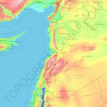
Nombre: Mapa topográfico Akkar, altitud, relieve.
Lugar: Akkar, Lebanon (31.95553 33.57596 37.15553 38.77596)
Altitud media: 418 m
Altitud mínima: -296 m
Altitud máxima: 2.980 m
Haz una donación
Otros mapas topográficos
Haga clic en un mapa para ver su topografía, su altitud y su relieve.
Haz una donación
Mount Lebanon Governorate
The governorate's altitude ranges from zero to 3,000 meters above sea level. It has diverse geographical features, including urban areas, mixed rural areas and natural areas. It is crossed by 5 rivers (Nahr El Kalb, Nahr Beirut, Damour, Awali River and Nahr Ibrahim) and includes the Shabrouh Dam with a…
Altitud media: 670 m
Haz una donación
South Governorate
South Governorate (Arabic: محافظة الجنوب, romanized: muḥāfaẓat al-Janūb, or simply الجنوب) is one of the governorates of Lebanon, with a population of 590,000 inhabitants and an area of 929.6 km2. The capital is Sidon. The lowest elevation is sea-level; the highest is 1,000 meters. The…
Altitud media: 250 m
Haz una donación
Sidon
The city of Sidon is administered by the Municipality of Sidon. The municipality is constituted of a council of 21 members including the City Mayor and his Deputy. It has administrative and financial independence but remains under the control and supervision of the central government, specifically the Ministry…
Altitud media: 38 m
Haz una donación
Zgharta District
The district at elevations from 40–2,550 metres (130–8,370 ft), from near the coast to its highest point in the Mount Lebanon mountain range.
Altitud media: 527 m
Baskinta
Lebanon > Mount Lebanon Governorate
Baskinta (Arabic: بسكنتا) is a Lebanese village situated at an altitude ranging from 1250 metres above sea level and climbs up to approximately 1800 meters of height at Qanat Bakish, making it one of the highest villages of Lebanon. It is located 43 kilometers north east of Beirut.
Altitud media: 1.396 m
Haz una donación
Baskinta
Lebanon > Mount Lebanon Governorate
Baskinta (Arabic: بسكنتا) is a Lebanese village situated at an altitude ranging from 1250 metres above sea level and climbs up to approximately 1800 meters of height at Qanat Bakish, making it one of the highest villages of Lebanon. It is located 43 kilometers north east of Beirut.
Altitud media: 1.396 m
Aley
Lebanon > Mount Lebanon Governorate
The word "Aley" means "high place" in Arabic and in Aramaic, referring to the city's high altitude above sea level (from 600m up to 950m).
Altitud media: 775 m
Haz una donación
Haz una donación
Faytroun
Lebanon > Keserwan-Jbeil Governorate
Faitroun (Arabic: فيطرون, romanized: Fayṭrūn; also spelled Faytroun) is a town in the Keserwan District of Keserwan-Jbeil Governorate. Located 33 kilometers north of Beirut and at an average altitude of 1,200 meters above sea level and its total land area of 743 hectares. Its inhabitants are…
Altitud media: 1.207 m
Haz una donación
Haz una donación
Mount Lebanon Governorate
The governorate's altitude ranges from zero to 3,000 meters above sea level. It has diverse geographical features, including urban areas, mixed rural areas and natural areas. It is crossed by 5 rivers (Nahr El Kalb, Nahr Beirut, Damour, Awali River and Nahr Ibrahim) and includes the Shabrouh Dam with a…
Altitud media: 660 m
Haz una donación
Haz una donación
Haz una donación
Haz una donación
Haz una donación
Ain Saadeh
Lebanon > Mount Lebanon Governorate
The average annual rainfall is 825 millimetres (32.5 in), with the large majority of it falling from October to April. Much of the autumn and spring rain falls in heavy downpours on a limited number of days, but in winter it is spread more evenly over many days. Summer receives very little rainfall, if any.…
Altitud media: 335 m
Haz una donación
Haz una donación
Haz una donación
Haz una donación
Haz una donación
Haz una donación
Haz una donación
Haz una donación
Haz una donación
Haz una donación
Haz una donación