
Mapa topográfico Raon-l'Étape
Mapa interactivo
Haga clic en el mapa para ver la altitud.
Acerca de este mapa
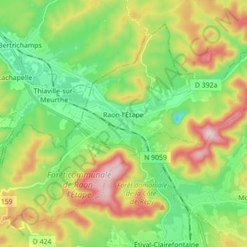
Nombre: Mapa topográfico Raon-l'Étape, altitud, relieve.
Altitud media: 362 m
Altitud mínima: 219 m
Altitud máxima: 604 m
Raon-l'Étape is positioned at the mouth of the Plaine [fr] at the point where it converges into the Meurthe, itself a tributary of the Moselle. Because it is on departmental frontier with the adjacent Meurthe-et-Moselle département, Raon-l'Étape is sometimes known as the "Gateway to the Vosges" (porte des Vosges). The town is positioned at a point where relatively flat lands transform into a much more mountainous topography: the mountains have for centuries restricted the options for travellers between francophone France and Alsace (formerly the western reaches of the Empire on the other side of the Vosges). The position of Raon has therefore been critical to influencing the movements of merchandise in peace time and of armies in war time for many centuries.
Otros mapas topográficos
Haga clic en un mapa para ver su topografía, su altitud y su relieve.
Dogneville
Dogneville, Épinal, Vosges, Grand Est, Metropolitan France, 88000, France
Altitud media: 337 m
Les Plombes
France > Grand Est > Vosges > Xonrupt-Longemer
Les Plombes, Xonrupt-Longemer, Saint-Dié-des-Vosges, Vosges, Grand Est, Metropolitan France, 88400, France
Altitud media: 882 m
Les Sources
France > Grand Est > Vosges > Bussang
Les Sources, Bussang, Épinal, Vosges, Grand Est, Metropolitan France, 88540, France
Altitud media: 806 m
Ramberchamp
France > Grand Est > Vosges > Gérardmer
Ramberchamp, Gérardmer, Saint-Dié-des-Vosges, Vosges, Grand Est, Metropolitan France, 88400, France
Altitud media: 786 m
La Petite-Fosse
La Petite-Fosse, Saint-Dié-des-Vosges, Vosges, Grand Est, Metropolitan France, 88490, France
Altitud media: 565 m
Maxey-sur-Meuse
Maxey-sur-Meuse, Neufchâteau, Vosges, Grand Est, Metropolitan France, 88630, France
Altitud media: 325 m
La Vôge-les-Bains
France > Grand Est > Vosges > La Vôge-les-Bains
La Vôge-les-Bains, Épinal, Vosges, Grand Est, Metropolitan France, 88240, France
Altitud media: 379 m
Bellefontaine
Bellefontaine, Épinal, Vosges, Grand Est, Metropolitan France, 88370, France
Altitud media: 544 m
Neufchâteau
Neufchâteau, Vosges, Grand Est, Metropolitan France, 88300, France
Altitud media: 334 m
La Croix-aux-Mines
La Croix-aux-Mines, Saint-Dié-des-Vosges, Vosges, Grand Est, Metropolitan France, 88520, France
Altitud media: 705 m
Ménil-sur-Belvitte
Ménil-sur-Belvitte, Épinal, Vosges, Grand Est, Metropolitan France, 88700, France
Altitud media: 315 m