
Haz una donación
Mapa topográfico Bdebba
Haga clic en el mapa para ver la altitud.
Haz una donación
Bdebba
The town of Bdebba is located in the Qada’a of Koura in the North governorate at an average altitude of 900 feet (270 meters) above sea level. Bdebba is 45 miles (72 kilometers) north of Beirut 3.5 miles (5.6 kilometers) east of the Mediterranean sea and 6 miles (9.7 kilometers) south of Tripoli (Trablous) Lebanon 2nd largest city. The town extends over an area of approximately 462 acres, (1 ft (0.30 m)²)most of the land is planted with olive trees.
Haz una donación
Acerca de este mapa
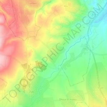
Nombre: Mapa topográfico Bdebba, altitud, relieve.
Lugar: Bdebba, Koura District, North Governorate, 1306, Lebanon (34.32679 35.79995 34.36679 35.83995)
Altitud media: 283 m
Altitud mínima: 193 m
Altitud máxima: 382 m
Haz una donación
Otros mapas topográficos
Haga clic en un mapa para ver su topografía, su altitud y su relieve.
Zgharta District
The district at elevations from 40–2,550 metres (130–8,370 ft), from near the coast to its highest point in the Mount Lebanon mountain range.
Altitud media: 527 m
Haz una donación
Haz una donación
Tripoli
The urban form of Mamluk Tripoli was dictated mainly by climate, site configuration, defense, and urban aesthetics. The layout of major thoroughfares was set according to prevailing winds and topography. The city had no fortifications, but heavy building construction characterized by compact urban forms,…
Altitud media: 42 m
Haz una donación
Haz una donación
Haz una donación
Haz una donación
Tripoli
The urban form of Mamluk Tripoli was dictated mainly by climate, site configuration, defense, and urban aesthetics. The layout of major thoroughfares was set according to prevailing winds and topography. The city had no fortifications, but heavy building construction characterized by compact urban forms,…
Altitud media: 42 m
Miniyeh
Miniyeh (Arabic: المنية, French: Minieh) is the capital of the Miniyeh-Danniyeh District in North Governorate of Lebanon. Minya is located 96 km from Beirut at an altitude of 20 m above sea level.
Altitud media: 30 m
Tripoli
The urban form of Mamluk Tripoli was dictated mainly by climate, site configuration, defense, and urban aesthetics. The layout of major thoroughfares was set according to prevailing winds and topography. The city had no fortifications, but heavy building construction characterized by compact urban forms,…
Altitud media: 42 m
Haz una donación
Haz una donación