
Mapa topográfico Gilgit
Mapa interactivo
Haga clic en el mapa para ver la altitud.
Gilgit
Gilgit lacks significant rainfall, averaging in 120 to 240 mm (4.7 to 9.4 in) annually, as monsoon breaks against the southern range of Himalayas. Irrigation for land cultivation is obtained from the rivers, abundant with melting snow water from higher altitudes.
Acerca de este mapa
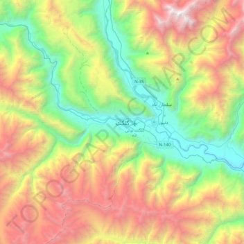
Nombre: Mapa topográfico Gilgit, altitud, relieve.
Altitud media: 3.002 m
Altitud mínima: 1.340 m
Altitud máxima: 5.626 m
Otros mapas topográficos
Haga clic en un mapa para ver su topografía, su altitud y su relieve.