
Gracias por apoyar a este sitio ❤️
Haz una donación
Haz una donación
Mapa topográfico St. Austell
Haga clic en el mapa para ver la altitud.
Gracias por apoyar a este sitio ❤️
Haz una donación
Haz una donación
Acerca de este mapa
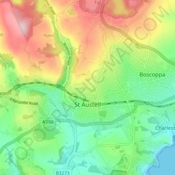
Nombre: Mapa topográfico St. Austell, altitud, relieve.
Lugar: St. Austell, Cornwall, England, United Kingdom (50.32947 -4.81398 50.35535 -4.74967)
Altitud media: 104 m
Altitud mínima: 0 m
Altitud máxima: 262 m
Gracias por apoyar a este sitio ❤️
Haz una donación
Haz una donación
Otros mapas topográficos
Haga clic en un mapa para ver su topografía, su altitud y su relieve.