
Haz una donación
Mapa topográfico Hillside
Haga clic en el mapa para ver la altitud.
Haz una donación
Acerca de este mapa
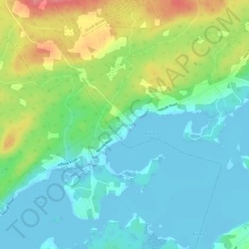
Nombre: Mapa topográfico Hillside, altitud, relieve.
Altitud media: 26 m
Altitud mínima: -3 m
Altitud máxima: 85 m
Haz una donación
Otros mapas topográficos
Haga clic en un mapa para ver su topografía, su altitud y su relieve.
Haz una donación
Haz una donación
Sydney
Canada > Nova Scotia > Cape Breton Regional Municipality
Sydney is on the east bank of the Sydney River where it discharges into South Arm of Sydney Harbour. Elevation ranges from sea level to 66 m (217 ft) above sea level.
Altitud media: 30 m
Haz una donación
Haz una donación
Haz una donación
Haz una donación
Boularderie Island
Canada > Nova Scotia > Cape Breton Regional Municipality > Southside Boularderie
Altitud media: 75 m
Haz una donación
Brown Islands
Canada > Nova Scotia > Cape Breton Regional Municipality > Main-à-Dieu
Altitud media: 0 m
Haz una donación
Haz una donación
Haz una donación
Haz una donación
Sydney
Canada > Nova Scotia > Cape Breton Regional Municipality
Sydney is on the east bank of the Sydney River where it discharges into South Arm of Sydney Harbour. Elevation ranges from sea level to 66 m (217 ft) above sea level.
Altitud media: 30 m
Haz una donación
Sydney
Canada > Nova Scotia > Cape Breton Regional Municipality
Sydney is on the east bank of the Sydney River where it discharges into South Arm of Sydney Harbour. Elevation ranges from sea level to 66 m (217 ft) above sea level.
Altitud media: 30 m