
Gracias por apoyar a este sitio ❤️
Haz una donación
Haz una donación
Mapa topográfico Arthur Seat
Haga clic en el mapa para ver la altitud.
Gracias por apoyar a este sitio ❤️
Haz una donación
Haz una donación
Acerca de este mapa
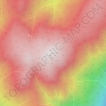
Nombre: Mapa topográfico Arthur Seat, altitud, relieve.
Altitud media: 1.327 m
Altitud mínima: 511 m
Altitud máxima: 1.656 m
Gracias por apoyar a este sitio ❤️
Haz una donación
Haz una donación
Otros mapas topográficos
Haga clic en un mapa para ver su topografía, su altitud y su relieve.
Barnes Lake
Canada > British Columbia > Thompson-Nicola Regional District > Area I (Blue Sky Country)
Altitud media: 752 m
Walhachin
Canada > British Columbia > Thompson-Nicola Regional District > Area I (Blue Sky Country)
In December 1914, the westward advance of the CNoR rail head from Kamloops reached Walhachin. The track follows the valley floor at a much lower elevation than the hamlet proper.
Altitud media: 438 m
Blue Earth Lake
Canada > British Columbia > Thompson-Nicola Regional District > Area I (Blue Sky Country)
Altitud media: 1.525 m