
Mapa topográfico Draper
Mapa interactivo
Haga clic en el mapa para ver la altitud.
Draper
Draper's climate is roughly identical to that of other Salt Lake City suburbs. However, due to being further away from the Great Salt Lake, varied elevation, and from the downtown urban heat island effect, Draper experiences a slightly drier winter, and more extremes in temperatures.
Acerca de este mapa
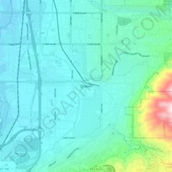
Nombre: Mapa topográfico Draper, altitud, relieve.
Lugar: Draper, Salt Lake County, Utah, 84020, United States (40.48478 -111.90280 40.56478 -111.82280)
Altitud media: 1.464 m
Altitud mínima: 1.313 m
Altitud máxima: 2.333 m