
Mapa topográfico Taylor Mill
Mapa interactivo
Haga clic en el mapa para ver la altitud.
Acerca de este mapa
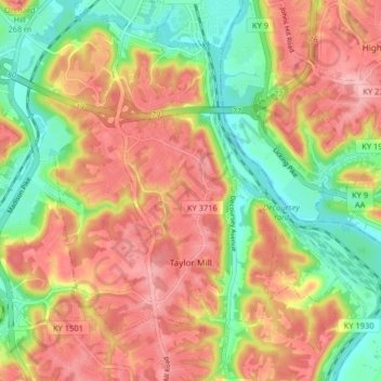
Nombre: Mapa topográfico Taylor Mill, altitud, relieve.
Lugar: Taylor Mill, Kenton County, Kentucky, 41015, United States (38.97794 -84.52537 39.04084 -84.45057)
Altitud media: 211 m
Altitud mínima: 138 m
Altitud máxima: 277 m
Otros mapas topográficos
Haga clic en un mapa para ver su topografía, su altitud y su relieve.
Morning View
United States > Kentucky > Kenton County
Morning View, Kenton County, Kentucky, 41063, United States
Altitud media: 192 m
Villa Hills
United States > Kentucky > Kenton County
Villa Hills, Kenton County, Kentucky, United States
Altitud media: 224 m
Covington
United States > Kentucky > Kenton County > Covington
Covington, Kenton County, Kentucky, United States
Altitud media: 215 m
Sunny Acres
United States > Kentucky > Kenton County > Taylor Mill > Sunny Acres
Sunny Acres, Taylor Mill, Kenton County, Kentucky, 41015, United States
Altitud media: 216 m
Lakeside Park
United States > Kentucky > Kenton County
Lakeside Park, Kenton County, Kentucky, 41017, United States
Altitud media: 255 m