
Haz una donación
Mapa topográfico Granite Lake
Haga clic en el mapa para ver la altitud.
Haz una donación
Acerca de este mapa
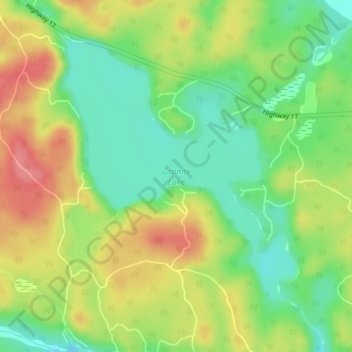
Nombre: Mapa topográfico Granite Lake, altitud, relieve.
Altitud media: 355 m
Altitud mínima: 319 m
Altitud máxima: 397 m
Haz una donación
Otros mapas topográficos
Haga clic en un mapa para ver su topografía, su altitud y su relieve.
lac Seul
Canada > Ontario > Kenora District > Unorganized Kenora District
Lac Seul is a large, crescent shaped reservoir in Kenora District, northwestern Ontario, Canada. It is approximately 241 km (150 mi) long. It has a maximum (regulated) depth of 47.2 m, with a surface elevation of 357 m above sea level. Its level is raised in the summer and then drawn down in the winter months…
Altitud media: 374 m
Haz una donación
Haz una donación
Hudson Bay Lowlands
Canada > Ontario > Kenora District > Unorganized Kenora District
Altitud media: 17 m
Haz una donación
Haz una donación
Confederation Lake
Canada > Ontario > Kenora District > Unorganized Kenora District
Altitud media: 414 m
Haz una donación
Haz una donación
Haz una donación
Haz una donación
Haz una donación
Haz una donación
Haz una donación
Haz una donación
Haz una donación
Haz una donación