
Mapa topográfico Guangzhou City
Mapa interactivo
Haga clic en el mapa para ver la altitud.
Acerca de este mapa
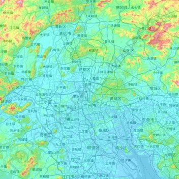
Nombre: Mapa topográfico Guangzhou City, altitud, relieve.
Lugar: Guangzhou City, Guangdong Province, China (22.56080 112.95237 23.93566 114.05476)
Altitud media: 98 m
Altitud mínima: -10 m
Altitud máxima: 1.236 m
The elevation of the prefecture generally increases from southwest to northeast, with mountains forming the backbone of the city and the ocean comprising the front. Tiantang Peak (simplified Chinese: 天堂顶; traditional Chinese: 天堂頂, "Heavenly Peak") is the highest point of elevation at 1,210 m (3,970 ft) above sea level.
Otros mapas topográficos
Haga clic en un mapa para ver su topografía, su altitud y su relieve.
Dongguan
China > Guangdong Province > Dongguan
Dongguan, Guangdong Province, 523058, China
Altitud media: 20 m
Shaxi
China > Guangdong Province > Zhongshan > Shaxi > Shenmingtingcun
Shaxi, Zhongshan, Shenmingtingcun, Guangdong Province, China
Altitud media: 8 m
Hangcheng Sub-district
China > Guangdong Province > Bao'an District > Hangcheng Sub-district
Hangcheng Sub-district, Bao'an District, Shenzhen, Guangdong Province, 518100, China
Altitud media: 21 m