
Mapa topográfico Clay Gates
Haga clic en el mapa para ver la altitud.
Acerca de este mapa
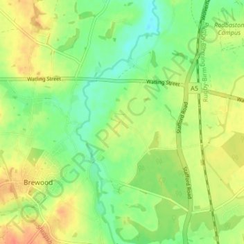
Nombre: Mapa topográfico Clay Gates, altitud, relieve.
Altitud media: 100 m
Altitud mínima: 79 m
Altitud máxima: 122 m
Otros mapas topográficos
Haga clic en un mapa para ver su topografía, su altitud y su relieve.
Weston Park
United Kingdom > England > Staffordshire > South Staffordshire > Weston under Lizard
Altitud media: 113 m
Highgate Common
United Kingdom > England > Staffordshire > South Staffordshire > Enville
Altitud media: 92 m
Mottey Meadows NNR
United Kingdom > England > Staffordshire > South Staffordshire > Wheaton Aston
Altitud media: 110 m
Shareshill
United Kingdom > England > Staffordshire > South Staffordshire > Shareshill
Altitud media: 123 m
Baggeridge Country Park
United Kingdom > England > Staffordshire > South Staffordshire
Altitud media: 146 m
Wombourne
United Kingdom > England > Staffordshire > South Staffordshire > Wombourne
Altitud media: 112 m
Cannock Lake
United Kingdom > England > Staffordshire > South Staffordshire > Huntington
Altitud media: 149 m