
Mapa topográfico Lošinj
Mapa interactivo
Haga clic en el mapa para ver la altitud.
Acerca de este mapa
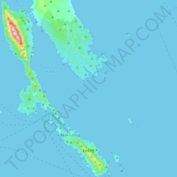
Nombre: Mapa topográfico Lošinj, altitud, relieve.
Altitud media: 14 m
Altitud mínima: -2 m
Altitud máxima: 569 m
Lošinj is part of the Cres-Lošinj archipelago. The Cres-Lošinj archipelago includes Cres and Lošinj, and the smaller islands of Unije, Ilovik, Susak, Vele Srakane, Male Srakane and a number of uninhabited small islands. Cres is the biggest by area, Lošinj is second. Cres and Lošinj are connected by a small bridge at the town of Osor on Cres. The highest elevations are the mountains Televrin (also called Osoršćica) at 588 m (1,929 ft) and Sv. Nikola (also called Sv. Mikul) at 557 m (1,827 ft). The towns of Nerezine and Sveti Jakov lie at their base. The island is formed predominantly of chalk limestone and dolomite rocks. There are sand deposits in the western part of the Kurila peninsula.