
Haz una donación
Mapa topográfico Dagger Lake
Haga clic en el mapa para ver la altitud.
Haz una donación
Acerca de este mapa
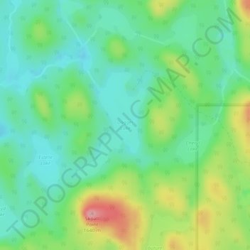
Nombre: Mapa topográfico Dagger Lake, altitud, relieve.
Altitud media: 1.484 m
Altitud mínima: 1.440 m
Altitud máxima: 1.578 m
Haz una donación
Otros mapas topográficos
Haga clic en un mapa para ver su topografía, su altitud y su relieve.
Dunn Peak
Canada > British Columbia > Thompson-Nicola Regional District > Area O (Lower North Thompson)
Altitud media: 2.132 m
Adams Lake
Canada > British Columbia > Thompson-Nicola Regional District > Area O (Lower North Thompson)
According to one account, the lake is 63 kilometres (39 mi) long and 1.6 to 3.2 kilometres (1.0 to 2.0 mi) wide. The surface elevation is 404 metres (1,325 ft) above sea level. The mean depth of 299 metres (981 ft) and maximum depth of 457 metres (1,499 ft) make the second deepest lake in BC (next to Quesnel…
Altitud media: 1.177 m
Mount Cahilty
Canada > British Columbia > Thompson-Nicola Regional District > Area O (Lower North Thompson)
Altitud media: 1.736 m
Community Lake
Canada > British Columbia > Thompson-Nicola Regional District > Area O (Lower North Thompson)
Altitud media: 1.399 m
Haz una donación
Bonaparte Lake
Canada > British Columbia > Thompson-Nicola Regional District > Area O (Lower North Thompson)
Altitud media: 1.383 m