
Haz una donación
Mapa topográfico Staythorpe CP
Haga clic en el mapa para ver la altitud.
Haz una donación
Staythorpe CP
The land is very low-lying and level, varying little in elevation between 12–14 metres (39–46 ft) throughout.
Haz una donación
Acerca de este mapa
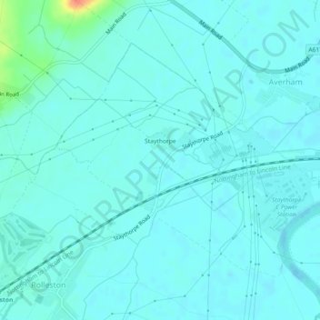
Nombre: Mapa topográfico Staythorpe CP, altitud, relieve.
Altitud media: 16 m
Altitud mínima: 9 m
Altitud máxima: 58 m
Haz una donación
Otros mapas topográficos
Haga clic en un mapa para ver su topografía, su altitud y su relieve.
Sherwood Forest NNR
United Kingdom > England > Nottinghamshire > Newark and Sherwood > Ollerton > Edwinstowe CP
Altitud media: 71 m
Haz una donación
Blidworth Bottoms
United Kingdom > England > Nottinghamshire > Newark and Sherwood > Blidworth CP
Altitud media: 107 m
Goverton
United Kingdom > England > Nottinghamshire > Newark and Sherwood > Bleasby
Altitud media: 34 m
Haz una donación
Vicar Water Country Park
United Kingdom > England > Nottinghamshire > Newark and Sherwood > Clipstone
Altitud media: 97 m
Haz una donación
Spalford Warren
United Kingdom > England > Nottinghamshire > Newark and Sherwood > Spalford
Altitud media: 7 m
Farndon
United Kingdom > England > Nottinghamshire > Newark and Sherwood > Farndon
Altitud media: 14 m
Haz una donación
Sherwood Forest NNR
United Kingdom > England > Nottinghamshire > Newark and Sherwood > Ollerton
Altitud media: 71 m