
Haz una donación
Mapa topográfico Fareham
Haga clic en el mapa para ver la altitud.
Haz una donación
Acerca de este mapa
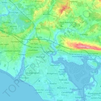
Nombre: Mapa topográfico Fareham, altitud, relieve.
Lugar: Fareham, Hampshire, England, United Kingdom (50.80894 -1.31291 50.89901 -1.11229)
Altitud media: 21 m
Altitud mínima: -4 m
Altitud máxima: 128 m
Haz una donación
Otros mapas topográficos
Haga clic en un mapa para ver su topografía, su altitud y su relieve.
Freefolk
United Kingdom > England > Hampshire > Basingstoke and Deane > Whitchurch
Altitud media: 101 m
Haz una donación
Basingstoke
United Kingdom > England > Hampshire > Basingstoke and Deane
Situated in a valley through the Hampshire Downs at an average elevation of 88 metres (289 ft) Basingstoke is a major interchange between Reading, Newbury, Andover, Winchester, and Alton, and lies on the natural trade route between the southwest of England and London. The area had been something of an…
Altitud media: 107 m
Haz una donación
Haz una donación