
Gracias por apoyar a este sitio ❤️
Haz una donación
Haz una donación
Mapa topográfico Great Dun Fell
Haga clic en el mapa para ver la altitud.
Gracias por apoyar a este sitio ❤️
Haz una donación
Haz una donación
Great Dun Fell
Under the Köppen climate classification, Great Dun Fell has a subpolar oceanic climate (Cfc), closely bordering both a subarctic climate (Dfc) under the 0 °C (32 °F) isotherm and an alpine tundra climate (ET) due to a July mean of exactly 10 °C (50 °F). The Met Office station publishes only temperature, wind and frost averages. The summers are cool due to elevation. Considering its elevation and a latitude of over 54 degrees, winters are relatively mild due to oceanic influences.
Gracias por apoyar a este sitio ❤️
Haz una donación
Haz una donación
Acerca de este mapa
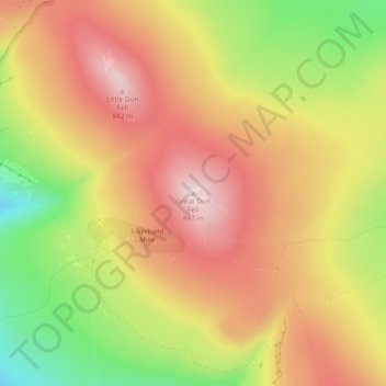
Nombre: Mapa topográfico Great Dun Fell, altitud, relieve.
Altitud media: 713 m
Altitud mínima: 526 m
Altitud máxima: 851 m
Gracias por apoyar a este sitio ❤️
Haz una donación
Haz una donación