
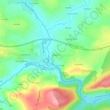
Mapa topográfico Le Poteau
Mapa interactivo
Haga clic en el mapa para ver la altitud.
Acerca de este mapa
Nombre: Mapa topográfico Le Poteau, altitud, relieve.
Altitud media: 168 m
Altitud mínima: 124 m
Altitud máxima: 250 m
Otros mapas topográficos
Haga clic en un mapa para ver su topografía, su altitud y su relieve.
Saint-Gelven
France > Bretagne > Côtes-d'Armor > Bon Repos sur Blavet
Saint-Gelven, Bon Repos sur Blavet, Guingamp, Côtes-d'Armor, Bretagne, France métropolitaine, 22570, France
Altitud media: 196 m
Bellevue
France > Bretagne > Côtes-d'Armor > Bon Repos sur Blavet
Bellevue, Saint-Gelven, Bon Repos sur Blavet, Guingamp, Côtes-d'Armor, Bretagne, France métropolitaine, 22570, France
Altitud media: 188 m
Stang Ar Goff
France > Bretagne > Côtes-d'Armor > Bon Repos sur Blavet > Stang Ar Goff
Stang Ar Goff, Laniscat, Bon Repos sur Blavet, Guingamp, Côtes-d'Armor, Bretagne, France métropolitaine, 22570, France
Altitud media: 172 m
Liscuis
France > Bretagne > Côtes-d'Armor > Bon Repos sur Blavet > Liscuis
Liscuis, Laniscat, Bon Repos sur Blavet, Guingamp, Côtes-d'Armor, Bretagne, France métropolitaine, 22570, France
Altitud media: 190 m
Laniscat
France > Bretagne > Côtes-d'Armor > Bon Repos sur Blavet
Laniscat, Bon Repos sur Blavet, Guingamp, Côtes-d'Armor, Bretagne, France métropolitaine, 22570, France
Altitud media: 178 m