
Haz una donación
Mapa topográfico Kusawa Lake
Haga clic en el mapa para ver la altitud.
Haz una donación
Kusawa Lake
Kusawa Lake is a lake in the southern Yukon, Canada. Kusawa means "long narrow lake" in the Tlingit language. The Kusawa Lake is a lake in Canada's Yukon Territory. It is located at an altitude of 671 m (2,201 ft) and is 60 km (37 mi) southwest of Whitehorse near the British Columbia border. It meanders over a length of 75 km (47 mi) with a maximum width of about 2.5 km (1.6 mi) through the mountains in the north of the Boundary Ranges. It is fed by the Primrose River and Kusawa River. The Takhini outflows to the Yukon River from the northern tip of Kusawa Lake. Kusawa Lake has an area of 142 km2 (55 sq mi). The lake has a maximum depth of 140 m (460 ft) and is of glacial origin. It is a common tourist destination and is also popular for fishing.
Haz una donación
Acerca de este mapa
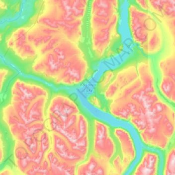
Nombre: Mapa topográfico Kusawa Lake, altitud, relieve.
Lugar: Kusawa Lake, Yukon, Canada (60.11043 -136.40772 60.60690 -136.03090)
Altitud media: 1.282 m
Altitud mínima: 681 m
Altitud máxima: 2.253 m
Haz una donación
Otros mapas topográficos
Haga clic en un mapa para ver su topografía, su altitud y su relieve.
Mount Logan
Due to active tectonic uplifting, Mount Logan is still rising in height (approximately 0.35 mm per year). Before 1992, the exact elevation of Mount Logan was unknown and measurements ranged from 5,959 to 6,050 metres (19,551 to 19,849 ft). In May 1992, a GSC expedition climbed Mount Logan and fixed the current…
Altitud media: 5.292 m
Haz una donación
Haz una donación
Haz una donación
Haz una donación
Haz una donación
Haz una donación
Mount Steele
Mount Steele is the fifth-highest mountain in Canada and either the tenth- or eleventh-highest peak in North America. Its exact elevation is uncertain. Commonly-quoted figures are 5,073 metres (16,644 ft) and 5,020 metres (16,470 ft). A lower southeast peak of Mt. Steele stands at 4,300 m (14,100 ft).
Altitud media: 4.446 m
Haz una donación
Haz una donación
Haz una donación
Haz una donación
Mount Logan
Mount Logan (/ˈloʊɡən/ LOH-ghən) is the highest mountain in Canada and the second-highest peak in North America after Denali. The mountain was named after Sir William Edmond Logan, a Canadian geologist and founder of the Geological Survey of Canada (GSC). Mount Logan is located within Kluane National Park…
Altitud media: 5.292 m
Haz una donación
Mount Logan
Mount Logan (/ˈloʊɡən/ LOH-ghən) is the highest mountain in Canada and the second-highest peak in North America after Denali (McKinley). The mountain was named after Sir William Edmond Logan, a Canadian geologist and founder of the Geological Survey of Canada (GSC). Mount Logan is located within Kluane…
Altitud media: 5.292 m
Haz una donación
Haz una donación
Haz una donación
Haz una donación
Mount Logan
Due to active tectonic uplifting, Mount Logan is still rising in height (approximately 0.35 mm per year). Before 1992, the exact elevation of Mount Logan was unknown and measurements ranged from 5,959 to 6,050 metres (19,551 to 19,849 ft). In May 1992, a GSC expedition climbed Mount Logan and fixed the current…
Altitud media: 5.292 m
Haz una donación