
Mapa topográfico Coos Bay
Mapa interactivo
Haga clic en el mapa para ver la altitud.
Acerca de este mapa
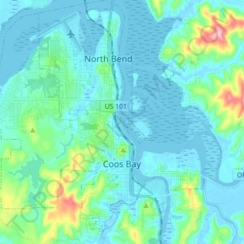
Nombre: Mapa topográfico Coos Bay, altitud, relieve.
Lugar: Coos Bay, Coos County, Oregon, 97420, United States (43.34296 -124.29044 43.42319 -124.16729)
Altitud media: 30 m
Altitud mínima: -4 m
Altitud máxima: 209 m
According to the United States Census Bureau, the city has a total area of 15.90 square miles (41.18 km2), of which, 10.60 square miles (27.45 km2) is land and 5.30 square miles (13.73 km2) is water. The city is quite hilly, with elevations ranging from between sea level to over 500 feet (150 m). Bodies of water within the city limits include Upper Pony Creek Reservoir, Lake Merritt, Empire Lakes and numerous streams.
Otros mapas topográficos
Haga clic en un mapa para ver su topografía, su altitud y su relieve.
Whiskey Run Beach
United States > Oregon > Coos County
Whiskey Run Beach, Coos County, Oregon, United States
Altitud media: 22 m
Coquille
United States > Oregon > Coos County
Coquille, Coos County, Oregon, United States
Altitud media: 40 m
North Bend
United States > Oregon > Coos County > North Bend
North Bend, Coos County, Oregon, United States
Altitud media: 11 m
Bandon
United States > Oregon > Coos County
Bandon, Coos County, Oregon, United States
Altitud media: 22 m