
Gracias por apoyar a este sitio ❤️
Haz una donación
Haz una donación
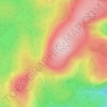
Mapa topográfico Notre Dame Mountains
Haga clic en el mapa para ver la altitud.
Gracias por apoyar a este sitio ❤️
Haz una donación
Haz una donación
Notre Dame Mountains
The Chic-Choc Mountains are one of the primary subranges of the Notre Dame Mountains. They are located in the northeastern part of the Gaspé Peninsula and are home to the tallest mountain in the range, Mont Jacques-Cartier, with an elevation of 1,268 m (4,160 ft). The other major subsection of the Notre Dame Mountains is the Massif du Sud, which is found in the southern part of the range, southeast of Quebec City, and reaches an elevation of 915 m (3,002 ft).
Gracias por apoyar a este sitio ❤️
Haz una donación
Haz una donación
Acerca de este mapa
Nombre: Mapa topográfico Notre Dame Mountains, altitud, relieve.
Altitud media: 1.128 m
Altitud mínima: 925 m
Altitud máxima: 1.276 m
Gracias por apoyar a este sitio ❤️
Haz una donación
Haz una donación