
Mapa topográfico Arciprestazgo de Alcalá Sur
Mapa interactivo
Haga clic en el mapa para ver la altitud.
Arciprestazgo de Alcalá Sur
Standing at an average altitude of 654 m, and occupying some 88 km2; the city was for a long time contained in between the Henares to the South and the Madrid-Barcelona railway to the North. However, the increasing population brought on the sprawl of the urbanised area to the area located in between the railway and the A-2 motorway and beyond.
Acerca de este mapa
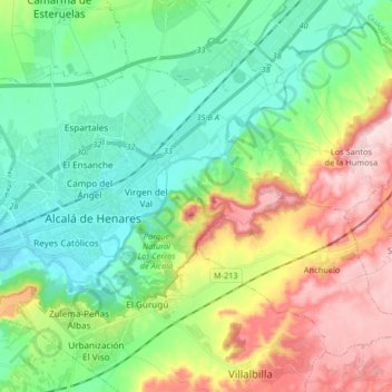
Nombre: Mapa topográfico Arciprestazgo de Alcalá Sur, altitud, relieve.
Altitud media: 685 m
Altitud mínima: 576 m
Altitud máxima: 899 m