
Mapa topográfico Kirkcaldy
Mapa interactivo
Haga clic en el mapa para ver la altitud.
Acerca de este mapa
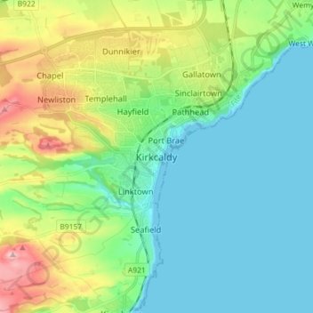
Nombre: Mapa topográfico Kirkcaldy, altitud, relieve.
Lugar: Kirkcaldy, Fife, Scotland, KY1 1JA, United Kingdom (56.07102 -3.19823 56.15102 -3.11823)
Altitud media: 50 m
Altitud mínima: -1 m
Altitud máxima: 185 m
Towards the end of the 16th century, a detailed assessment on the size of the townscape was carried out. The first estimate of the parish population in 1639 was between 3,000 and 3,200 and around 3,400 by 1691. At the beginning of the 18th century, the population declined. A census by Webster's Topographical Dictionary of Scotland in 1755, recorded an estimate of 2,296 in the parish. By the time of the first nationwide UK census in 1801, the population had risen to 3,248. The population of the burgh was recorded as 4,785 in the 1841 Census, and had risen to 34,079 by 1901. By the time of the 1951 Census, the figure stood at 49,050.
Otros mapas topográficos
Haga clic en un mapa para ver su topografía, su altitud y su relieve.
St Andrews
United Kingdom > Scotland > Fife
St Andrews, Fife, Scotland, KY16 9PA, United Kingdom
Altitud media: 38 m