
Gracias por apoyar a este sitio ❤️
Haz una donación
Haz una donación
Mapa topográfico Easter Island
Haga clic en el mapa para ver la altitud.
Gracias por apoyar a este sitio ❤️
Haz una donación
Haz una donación
Acerca de este mapa
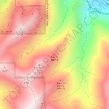
Nombre: Mapa topográfico Easter Island, altitud, relieve.
Lugar: Easter Island, King County, Washington, USA (47.42137 -121.67110 47.42147 -121.67100)
Altitud media: 966 m
Altitud mínima: 377 m
Altitud máxima: 1.323 m
Gracias por apoyar a este sitio ❤️
Haz una donación
Haz una donación
Otros mapas topográficos
Haga clic en un mapa para ver su topografía, su altitud y su relieve.