Haz una donación
Mapa topográfico Swithland
Haga clic en el mapa para ver la altitud.
Haz una donación
Acerca de este mapa
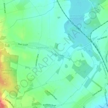
Nombre: Mapa topográfico Swithland, altitud, relieve.
Lugar: Swithland, Charnwood, Leicestershire, England, United Kingdom (52.69883 -1.20580 52.72337 -1.16418)
Altitud media: 74 m
Altitud mínima: 55 m
Altitud máxima: 128 m
Haz una donación
Otros mapas topográficos
Haga clic en un mapa para ver su topografía, su altitud y su relieve.
Six Hills
United Kingdom > England > Leicestershire > Charnwood > Burton on the Wolds
Altitud media: 128 m
Haz una donación
Beacon Hill Country Park
United Kingdom > England > Leicestershire > Charnwood > Woodhouse Eaves
Altitud media: 164 m
Haz una donación
Watermead Country Park
United Kingdom > England > Leicestershire > Charnwood > Birstall
Altitud media: 59 m
Haz una donación
Haz una donación
Bradgate Park
United Kingdom > England > Leicestershire > Charnwood > Newtown Linford
Overlying the Beacon Hill Formation, but found a little further down the hillside to the south, are the Bradgate Formation beds, the most notable of which is the Sliding Stone Slump Breccia rocks. Forming a line of crags below Old John, these are laminated mudstones, with layers of sandstone, mainly of…
Altitud media: 126 m
Haz una donación
Top Town Plantation
United Kingdom > England > Leicestershire > Charnwood > Walton on the Wolds
Altitud media: 85 m
Haz una donación
