
Gracias por apoyar a este sitio ❤️
Haz una donación
Haz una donación
Mapa topográfico Spellbrook
Haga clic en el mapa para ver la altitud.
Gracias por apoyar a este sitio ❤️
Haz una donación
Haz una donación
Acerca de este mapa
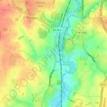
Nombre: Mapa topográfico Spellbrook, altitud, relieve.
Altitud media: 71 m
Altitud mínima: 47 m
Altitud máxima: 94 m
Gracias por apoyar a este sitio ❤️
Haz una donación
Haz una donación
Otros mapas topográficos
Haga clic en un mapa para ver su topografía, su altitud y su relieve.
Sawbridgeworth
United Kingdom > England > Hertfordshire > East Hertfordshire > Sawbridgeworth
Altitud media: 67 m
Sawbridgeworth
United Kingdom > England > Hertfordshire > East Hertfordshire > Sawbridgeworth
Altitud media: 67 m