
Mapa topográfico Lewis Pass
Mapa interactivo
Haga clic en el mapa para ver la altitud.
Acerca de este mapa
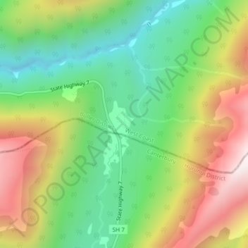
Nombre: Mapa topográfico Lewis Pass, altitud, relieve.
Lugar: Lewis Pass, Buller District, West Coast, New Zealand (-42.37855 172.40098 -42.37845 172.40108)
Altitud media: 1.039 m
Altitud mínima: 680 m
Altitud máxima: 1.547 m
Otros mapas topográficos
Haga clic en un mapa para ver su topografía, su altitud y su relieve.
Mokihinui
New Zealand > West Coast > Buller District
Mokihinui, Buller District, West Coast, New Zealand
Altitud media: 55 m
Charleston
New Zealand > West Coast > Buller District
Charleston, Buller District, West Coast, New Zealand
Altitud media: 24 m
Granity
New Zealand > West Coast > Buller District
Granity, Buller District, West Coast, New Zealand
Altitud media: 150 m
Cape Foulwind
New Zealand > West Coast > Buller District > Cape Foulwind
Cape Foulwind, Buller District, West Coast, New Zealand
Altitud media: 14 m
Hukarere
New Zealand > West Coast > Buller District
Hukarere, Buller District, West Coast, New Zealand
Altitud media: 131 m
Ikamatua
New Zealand > West Coast > Buller District
Ikamatua, Buller District, West Coast, New Zealand
Altitud media: 122 m
Westport
New Zealand > West Coast > Buller District
Westport, Buller District, West Coast, 7825, New Zealand
Altitud media: 13 m
Reefton
New Zealand > West Coast > Buller District
Reefton, Buller District, West Coast, 7830, New Zealand
Altitud media: 310 m