
Haz una donación
Mapa topográfico Bsharri
Haga clic en el mapa para ver la altitud.
Haz una donación
Bsharri
Bsharri (Arabic: بشرّي Bšarrī; also romanized Becharre, Bcharre, Bsharre, Bcharre Al Arz) is a Lebanese town located in the district of the same name, North Governorate, situated at altitudes between 1,100 m (3,600 ft) and 3,088 m (10,131 ft). Bsharri is the location of the Cedars of God, a UNESCO World Heritage Site and the only remaining place where the Cedrus libani (Lebanese cedar) tree grows natively. The region is the birthplace of famed poet, painter and sculptor Khalil Gibran; a museum in town honours his life and work.
Haz una donación
Acerca de este mapa
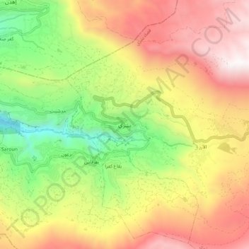
Nombre: Mapa topográfico Bsharri, altitud, relieve.
Altitud media: 1.847 m
Altitud mínima: 883 m
Altitud máxima: 2.831 m
Haz una donación
Otros mapas topográficos
Haga clic en un mapa para ver su topografía, su altitud y su relieve.
Zgharta District
The district at elevations from 40–2,550 metres (130–8,370 ft), from near the coast to its highest point in the Mount Lebanon mountain range.
Altitud media: 527 m
Haz una donación
Haz una donación
Tripoli
The urban form of Mamluk Tripoli was dictated mainly by climate, site configuration, defense, and urban aesthetics. The layout of major thoroughfares was set according to prevailing winds and topography. The city had no fortifications, but heavy building construction characterized by compact urban forms,…
Altitud media: 42 m
Haz una donación
Haz una donación
Haz una donación
Haz una donación
Tripoli
The urban form of Mamluk Tripoli was dictated mainly by climate, site configuration, defense, and urban aesthetics. The layout of major thoroughfares was set according to prevailing winds and topography. The city had no fortifications, but heavy building construction characterized by compact urban forms,…
Altitud media: 42 m
Miniyeh
Miniyeh (Arabic: المنية, French: Minieh) is the capital of the Miniyeh-Danniyeh District in North Governorate of Lebanon. Minya is located 96 km from Beirut at an altitude of 20 m above sea level.
Altitud media: 30 m
Tripoli
The urban form of Mamluk Tripoli was dictated mainly by climate, site configuration, defense, and urban aesthetics. The layout of major thoroughfares was set according to prevailing winds and topography. The city had no fortifications, but heavy building construction characterized by compact urban forms,…
Altitud media: 42 m
Haz una donación
Haz una donación