
Gracias por apoyar a este sitio ❤️
Haz una donación
Haz una donación
Mapa topográfico Orford
Haga clic en el mapa para ver la altitud.
Gracias por apoyar a este sitio ❤️
Haz una donación
Haz una donación
Acerca de este mapa
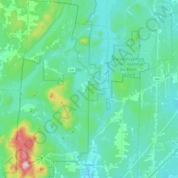
Nombre: Mapa topográfico Orford, altitud, relieve.
Lugar: Orford, Memphrémagog, Estrie, Quebec, Canada (45.30149 -72.25291 45.44979 -72.10536)
Altitud media: 319 m
Altitud mínima: 211 m
Altitud máxima: 842 m
Gracias por apoyar a este sitio ❤️
Haz una donación
Haz una donación
Otros mapas topográficos
Haga clic en un mapa para ver su topografía, su altitud y su relieve.
Scouts Canada - Lake Lovering Scouts Reserve
Canada > Quebec > Memphrémagog > Magog
Altitud media: 260 m
Gracias por apoyar a este sitio ❤️
Haz una donación
Haz una donación
Gracias por apoyar a este sitio ❤️
Haz una donación
Haz una donación