
Gracias por apoyar a este sitio ❤️
Haz una donación
Haz una donación
Mapa topográfico Chesney
Haga clic en el mapa para ver la altitud.
Gracias por apoyar a este sitio ❤️
Haz una donación
Haz una donación
Acerca de este mapa
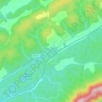
Nombre: Mapa topográfico Chesney, altitud, relieve.
Altitud media: 403 m
Altitud mínima: 297 m
Altitud máxima: 654 m
Gracias por apoyar a este sitio ❤️
Haz una donación
Haz una donación
Otros mapas topográficos
Haga clic en un mapa para ver su topografía, su altitud y su relieve.
Big Ridge State Park
United States > Tennessee > Union County
Big Ridge State Park is located in the Appalachian Ridge-and-Valley range, which is characterized by narrow elongate ridges flanked by fertile stream valleys. The park's topography is dominated by three such ridge systems running roughly parallel to one another, the two northernmost of which are bisected by…
Altitud media: 352 m