
Mapa topográfico Ballinknockane
Mapa interactivo
Haga clic en el mapa para ver la altitud.
Acerca de este mapa
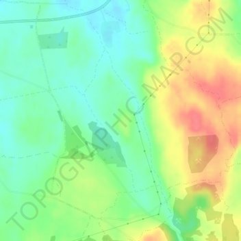
Nombre: Mapa topográfico Ballinknockane, altitud, relieve.
Altitud media: 27 m
Altitud mínima: 1 m
Altitud máxima: 64 m
Otros mapas topográficos
Haga clic en un mapa para ver su topografía, su altitud y su relieve.
Knocknabooly East
Ireland > The Municipal District of Adare — Rathkeale
Knocknabooly East, Loghill, The Municipal District of Adare — Rathkeale, County Limerick, Munster, Ireland
Altitud media: 105 m
Glendiheen
Ireland > The Municipal District of Adare — Rathkeale
Glendiheen, Dunmoylan East, The Municipal District of Adare — Rathkeale, County Limerick, Munster, Ireland
Altitud media: 167 m
Shanagolden
Ireland > The Municipal District of Adare — Rathkeale
Shanagolden, The Municipal District of Adare — Rathkeale, County Limerick, Munster, Ireland
Altitud media: 40 m
Pallaskenry
Ireland > The Municipal District of Adare — Rathkeale
Pallaskenry, The Municipal District of Adare — Rathkeale, County Limerick, Munster, Ireland
Altitud media: 11 m
Loghill
Ireland > The Municipal District of Adare — Rathkeale
Loghill, The Municipal District of Adare — Rathkeale, County Limerick, Munster, Ireland
Altitud media: 69 m
Inchinclare
Ireland > The Municipal District of Adare — Rathkeale
Inchinclare, Ballynabanoge, The Municipal District of Adare — Rathkeale, County Limerick, Munster, Ireland
Altitud media: 41 m
Clonshire Beg
Ireland > The Municipal District of Adare — Rathkeale
Clonshire Beg, Croagh, The Municipal District of Adare — Rathkeale, County Limerick, Munster, Ireland
Altitud media: 13 m
Foynes Island
Ireland > The Municipal District of Adare — Rathkeale
Foynes Island, Shanagolden, The Municipal District of Adare — Rathkeale, County Limerick, Munster, Ireland
Altitud media: 10 m
Kildimo
Ireland > The Municipal District of Adare — Rathkeale
Kildimo, The Municipal District of Adare — Rathkeale, County Limerick, Munster, Ireland
Altitud media: 14 m