
Gracias por apoyar a este sitio ❤️
Haz una donación
Haz una donación
Mapa topográfico Hoodoo
Haga clic en el mapa para ver la altitud.
Gracias por apoyar a este sitio ❤️
Haz una donación
Haz una donación
Acerca de este mapa
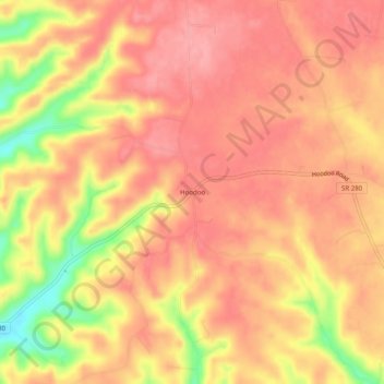
Nombre: Mapa topográfico Hoodoo, altitud, relieve.
Altitud media: 364 m
Altitud mínima: 290 m
Altitud máxima: 394 m
Gracias por apoyar a este sitio ❤️
Haz una donación
Haz una donación
Otros mapas topográficos
Haga clic en un mapa para ver su topografía, su altitud y su relieve.
Old Stone Fort State Archaeological Park
United States > Tennessee > Coffee County > Manchester
The Duck River system spills over a limestone-rich shelf of the western Cumberland Plateau known as the Highland Rim. As the Duck and Little Duck approach their convergence, they rapidly drop in elevation, and have cut relatively deep gorges around the peninsula upon which the ancient structure is located.…
Altitud media: 316 m
Lake Tullahoma
United States > Tennessee > Coffee County > Tullahoma > Lake Tullahoma Estates
Altitud media: 322 m