
Gracias por apoyar a este sitio ❤️
Haz una donación
Haz una donación
Mapa topográfico Pentre-du
Haga clic en el mapa para ver la altitud.
Gracias por apoyar a este sitio ❤️
Haz una donación
Haz una donación
Acerca de este mapa
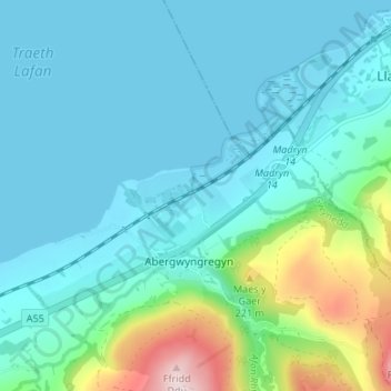
Nombre: Mapa topográfico Pentre-du, altitud, relieve.
Altitud media: 66 m
Altitud mínima: -1 m
Altitud máxima: 371 m
Gracias por apoyar a este sitio ❤️
Haz una donación
Haz una donación
Otros mapas topográficos
Haga clic en un mapa para ver su topografía, su altitud y su relieve.
Carneddau
United Kingdom > Wales > Gwynedd > Abergwyngregyn
The plants growing on the Carneddau need to be extremely hardy to withstand the snow, frosts, and gales they will encounter during the year and those found by sheltered streams in the valleys are very different from those clinging to crevices on windswept rocks. Sheep graze the mountains and impact the…
Altitud media: 408 m