
Gracias por apoyar a este sitio ❤️
Haz una donación
Haz una donación
Mapa topográfico Fell Foot
Haga clic en el mapa para ver la altitud.
Gracias por apoyar a este sitio ❤️
Haz una donación
Haz una donación
Acerca de este mapa
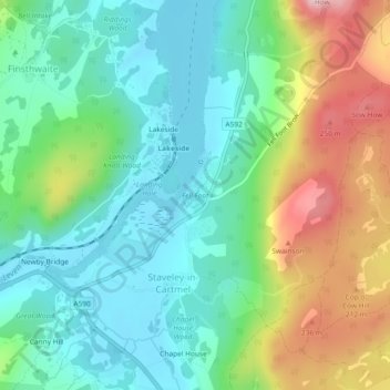
Nombre: Mapa topográfico Fell Foot, altitud, relieve.
Altitud media: 117 m
Altitud mínima: 39 m
Altitud máxima: 285 m
Gracias por apoyar a este sitio ❤️
Haz una donación
Haz una donación
Otros mapas topográficos
Haga clic en un mapa para ver su topografía, su altitud y su relieve.
Newby Bridge
United Kingdom > England > Westmorland and Furness > Staveley-in-Cartmel
Altitud media: 109 m
Staveley-in-Cartmel
United Kingdom > England > Westmorland and Furness > Staveley-in-Cartmel
Altitud media: 110 m