
Mapa topográfico Warwick
Mapa interactivo
Haga clic en el mapa para ver la altitud.
Acerca de este mapa
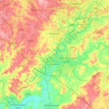
Nombre: Mapa topográfico Warwick, altitud, relieve.
Lugar: Warwick, Warwickshire, England, United Kingdom (52.21370 -1.78018 52.38928 -1.40608)
Altitud media: 87 m
Altitud mínima: 35 m
Altitud máxima: 145 m
Warwick experiences the usual English maritime climate, marked by a narrow temperature range, mild winters and cool summers. The nearest official Met Office weather station is at Wellesbourne, about 6 miles (10 km) south of the town centre and at a similar elevation. The absolute maximum temperature (also the absolute maximum for the county of Warwickshire) stands at 36.1 °C (97.0 °F) recorded in August 1990. During a typical year, the warmest day should reach 30.0 °C (86.0 °F), and 16.5 days should report a maximum of 25.1 °C (77.2 °F) or higher. The lowest recorded temperature is −17.8 °C (0.0 °F), recorded in January 1982. Typically, 53.3 air frosts are recorded in an "average" year. Rainfall averages out at 608 millimetres (23.9 in) per year, with over 114 days seeing 1 mm (0.04 in) or more falling. All averages refer to the 1971–2000 period.
Otros mapas topográficos
Haga clic en un mapa para ver su topografía, su altitud y su relieve.
Stratford-upon-Avon
United Kingdom > England > Warwickshire > Stratford-on-Avon
Stratford-upon-Avon, Stratford-on-Avon, Warwickshire, England, United Kingdom
Altitud media: 61 m
Newbold on Avon
United Kingdom > England > Warwickshire > Rugby
Newbold on Avon, Rugby, Warwickshire, England, CV21 1HQ, United Kingdom
Altitud media: 98 m
Bilton
United Kingdom > England > Warwickshire > Rugby
Bilton, Rugby, Warwickshire, England, CV22 7NL, United Kingdom
Altitud media: 111 m
Ilmington CP
United Kingdom > England > Warwickshire > Stratford-on-Avon
Ilmington CP, Stratford-on-Avon, Warwickshire, England, United Kingdom
Altitud media: 123 m
Great Alne
United Kingdom > England > Warwickshire > Stratford-on-Avon
Great Alne, Stratford-on-Avon, Warwickshire, England, B49 6HJ, United Kingdom
Altitud media: 64 m
Nuneaton
United Kingdom > England > Warwickshire > Nuneaton and Bedworth > Nuneaton
Nuneaton, Nuneaton and Bedworth, Warwickshire, West Midlands, England, CV11 5AB, United Kingdom
Altitud media: 101 m
Bedworth
United Kingdom > England > Warwickshire > Nuneaton and Bedworth > Bedworth
Bedworth, Nuneaton and Bedworth, Warwickshire, West Midlands, England, CV12 9DQ, United Kingdom
Altitud media: 105 m
West Midlands
United Kingdom > England > Warwickshire
West Midlands, Warwickshire, West Midlands Combined Authority, England, United Kingdom
Altitud media: 113 m
Rugby
United Kingdom > England > Warwickshire
Rugby, Warwickshire, England, United Kingdom
Altitud media: 112 m
Stratford-upon-Avon
United Kingdom > England > Warwickshire > Stratford-on-Avon > Stratford-upon-Avon
Stratford-upon-Avon, Stratford-on-Avon, Warwickshire, West Midlands, England, CV37 6AH, United Kingdom
Altitud media: 58 m
Nuneaton and Bedworth
United Kingdom > England > Warwickshire
Nuneaton and Bedworth, Warwickshire, England, United Kingdom
Altitud media: 108 m