
Mapa topográfico Long Lawford
Mapa interactivo
Haga clic en el mapa para ver la altitud.
Acerca de este mapa
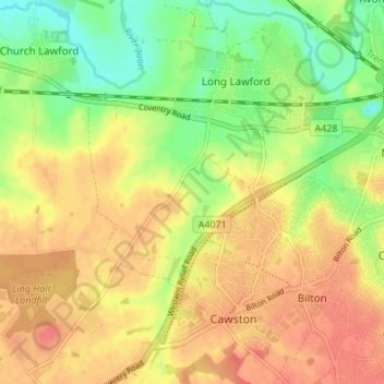
Nombre: Mapa topográfico Long Lawford, altitud, relieve.
Altitud media: 101 m
Altitud mínima: 71 m
Altitud máxima: 124 m
Otros mapas topográficos
Haga clic en un mapa para ver su topografía, su altitud y su relieve.
Marton CP
United Kingdom > England > Rugby > Marton CP
Marton CP, Rugby, Warwickshire, West Midlands, England, United Kingdom
Altitud media: 71 m
Princethorpe
United Kingdom > England > Rugby > Princethorpe
Princethorpe, Rugby, Warwickshire, England, CV23 9QW, United Kingdom
Altitud media: 86 m
Coton House Estate
United Kingdom > England > Rugby
Coton House Estate, Churchover CP, Rugby, Warwickshire, West Midlands, England, CV23 0UT, United Kingdom
Altitud media: 121 m