
Mapa topográfico Quarndon
Mapa interactivo
Haga clic en el mapa para ver la altitud.
Quarndon
52°58′8″N 1°29′36″W / 52.96889°N 1.49333°W / 52.96889; -1.49333 This directional compass, provides details of bearings, distances, elevations and dates of nearly 50 places of special interest and was unveiled on 29 September 2001. It stands on an 8-ton block of Derbyshire gritstone – 140 metres above sea level – funded by the will of the third Viscount Scarsdale who died in 2000 aged 76.
Acerca de este mapa
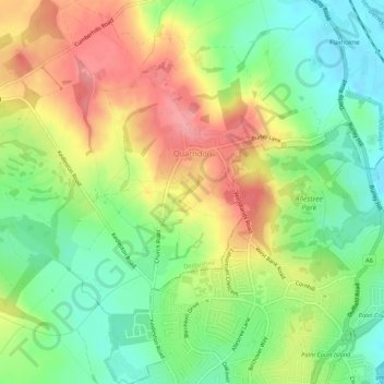
Nombre: Mapa topográfico Quarndon, altitud, relieve.
Lugar: Quarndon, Amber Valley, Derbyshire, England, United Kingdom (52.94631 -1.52417 52.97845 -1.48333)
Altitud media: 96 m
Altitud mínima: 51 m
Altitud máxima: 149 m
Otros mapas topográficos
Haga clic en un mapa para ver su topografía, su altitud y su relieve.