
Haz una donación
Mapa topográfico Beith
Haga clic en el mapa para ver la altitud.
Haz una donación
Acerca de este mapa
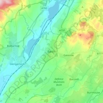
Nombre: Mapa topográfico Beith, altitud, relieve.
Lugar: Beith, North Ayrshire, Scotland, KA15 1BS, United Kingdom (55.71071 -4.67278 55.79071 -4.59278)
Altitud media: 92 m
Altitud mínima: 23 m
Altitud máxima: 297 m
Haz una donación
Otros mapas topográficos
Haga clic en un mapa para ver su topografía, su altitud y su relieve.
Isle of Arran
United Kingdom > Scotland > North Ayrshire
The island has three endemic species of tree, the Arran whitebeams. These trees are the Scottish or Arran whitebeam (Sorbus arranensis), the bastard mountain ash or cut-leaved whitebeam (Sorbus pseudofennica) and the Catacol whitebeam (Sorbus pseudomeinichii). If rarity is measured by numbers alone they are…
Altitud media: 98 m
Haz una donación