
Mapa topográfico Yushu Tibetan Autonomous Prefecture
Mapa interactivo
Haga clic en el mapa para ver la altitud.
Acerca de este mapa
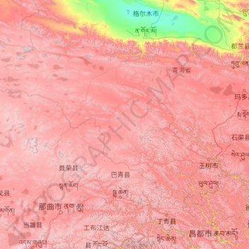
Nombre: Mapa topográfico Yushu Tibetan Autonomous Prefecture, altitud, relieve.
Lugar: Yushu Tibetan Autonomous Prefecture, Qinghai, China (31.60180 89.40222 36.28011 97.75823)
Altitud media: 4.472 m
Altitud mínima: 2.678 m
Altitud máxima: 6.537 m
With elevations above 3,600 metres (12,000 ft), the prefecture has a harsh climate, with long, cold winters, and short, rainy, and cool to warm summers. Specifically, in the Köppen system, the prefecture ranges from the alpine variation of the subarctic climate (Köppen Dwc), to a full alpine climate (Köppen EH), to a semi-arid climate (Köppen BSk).[9] Most of the annual precipitation occurs from June to September, when on average, a majority of the days each month has some rainfall. The annual mean temperature in Yushu County, at an elevation of 3,690 metres (12,110 ft), is 3.22 °C (37.8 °F) and in Qumarlêb, in the northeast of the prefecture at 4,190 m (13,750 ft) elevation, −2.13 °C (28.2 °F). Sunshine is generous, ranging from around 2500 hours in the prefecture seat to 2780 hours in Qumarlêb.
Otros mapas topográficos
Haga clic en un mapa para ver su topografía, su altitud y su relieve.
Tanggulashan
Tanggulashan, Golmud, Haixi Mongol and Tibetan Autonomous Prefecture, Qinghai, China
Altitud media: 4.756 m
Golmud City
Golmud City, Haixi Mongol and Tibetan Autonomous Prefecture, Qinghai, 816099, China
Altitud media: 4.324 m
Qumarlêb County
Qumarlêb County, Yushu Tibetan Autonomous Prefecture, Qinghai, China
Altitud media: 4.505 m
Huangnan
China > Qinghai > Tongren City
Huangnan, Tongren City, Huangnan Tibetan Autonomous Prefecture, Qinghai, China
Altitud media: 3.194 m
Golog Tibetan Autonomous Prefecture
China > Qinghai > Gadê County
Golog Tibetan Autonomous Prefecture, Gadê County, Golog Tibetan Autonomous Prefecture, Qinghai, China
Altitud media: 4.340 m
Lamu
China > Qinghai > Hualong Hui Autonomous County
Lamu, Hualong Hui Autonomous County, Haidong, Qinghai, China
Altitud media: 2.256 m
Xireg
China > Qinghai > Ulan County > Xireg
Xireg, Ulan County, Haixi Mongol and Tibetan Autonomous Prefecture, Qinghai, China
Altitud media: 3.248 m
Golog Tibetan Autonomous Prefecture
China > Qinghai > Maqên County > Golog Tibetan Autonomous Prefecture
Golog Tibetan Autonomous Prefecture, Maqên County, Golog Tibetan Autonomous Prefecture, Qinghai, China
Altitud media: 4.148 m
Tanggula Mountains
China > Qinghai > Yanshiping
Tanggula Mountains, Yanshiping, Golmud City, Haixi Mongol and Tibetan Autonomous Prefecture, Qinghai, China
Altitud media: 5.912 m