
Mapa topográfico Lac Thor
Mapa interactivo
Haga clic en el mapa para ver la altitud.
Acerca de este mapa
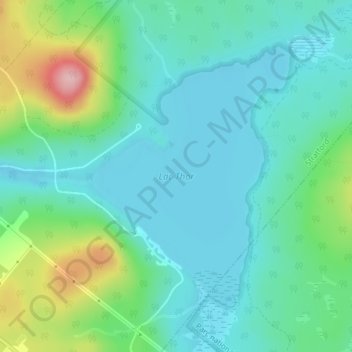
Nombre: Mapa topográfico Lac Thor, altitud, relieve.
Lugar: Lac Thor, Stratford, Le Granit, Estrie, Québec, Canada (45.76832 -71.24541 45.78839 -71.22347)
Altitud media: 336 m
Altitud mínima: 292 m
Altitud máxima: 475 m
Otros mapas topográficos
Haga clic en un mapa para ver su topografía, su altitud y su relieve.
Mont Aylmer
Mont Aylmer, Stratford, Le Granit, Estrie, Québec, Canada
Altitud media: 382 m