
Mapa topográfico La Grée
Mapa interactivo
Haga clic en el mapa para ver la altitud.
Acerca de este mapa
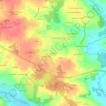
Nombre: Mapa topográfico La Grée, altitud, relieve.
Altitud media: 65 m
Altitud mínima: 25 m
Altitud máxima: 99 m
Otros mapas topográficos
Haga clic en un mapa para ver su topografía, su altitud y su relieve.
Beau Soleil
France > Bretagne > Morbihan > La Croix-Helléan
Beau Soleil, La Croix-Helléan, Pontivy, Morbihan, Bretagne, France métropolitaine, 56120, France
Altitud media: 67 m
La Ville Raffray
France > Bretagne > Morbihan > La Croix-Helléan
La Ville Raffray, La Croix-Helléan, Pontivy, Morbihan, Bretagne, France métropolitaine, 56120, France
Altitud media: 66 m