
Mapa topográfico Orkney Islands
Mapa interactivo
Haga clic en el mapa para ver la altitud.
Acerca de este mapa
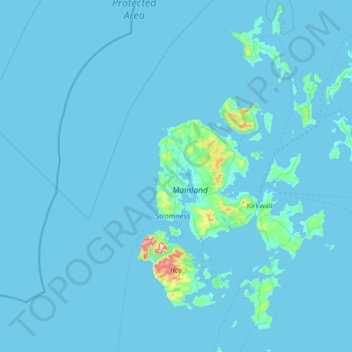
Nombre: Mapa topográfico Orkney Islands, altitud, relieve.
Lugar: Orkney Islands, Scotland, United Kingdom (58.68595 -3.43587 59.39272 -2.37048)
Altitud media: 9 m
Altitud mínima: -1 m
Altitud máxima: 468 m
The southern group of islands surrounds Scapa Flow. Hoy is the second largest of the Orkney Isles and Ward Hill at its northern end is the highest elevation in the archipelago. The Old Man of Hoy is a well-known seastack. Burray lies to the east of Scapa Flow and is linked by causeway to South Ronaldsay, which hosts the cultural events, the Festival of the Horse and the Boys' Ploughing Match on the third Saturday in August. It is also the location of the Neolithic Tomb of the Eagles. Graemsay and Flotta are both linked by ferry to the Mainland and Hoy, and the latter is known for its large oil terminal. South Walls has a 19th-century Martello tower and is connected to Hoy by the Ayre. South Ronaldsay, Burray, Glimps Holm, and Lamb Holm are connected by road to the Mainland by the Churchill Barriers.
Otros mapas topográficos
Haga clic en un mapa para ver su topografía, su altitud y su relieve.
Rendall
United Kingdom > Scotland > Orkney Islands
Rendall, Orkney Islands, Scotland, KW17 2NZ, United Kingdom
Altitud media: 42 m