
Haz una donación
Mapa topográfico Fairlight
Haga clic en el mapa para ver la altitud.
Haz una donación
Acerca de este mapa
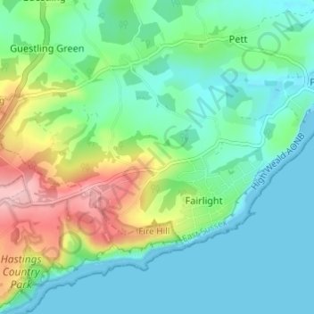
Nombre: Mapa topográfico Fairlight, altitud, relieve.
Lugar: Fairlight, Rother, East Sussex, England, United Kingdom (50.86960 0.62260 50.89147 0.68333)
Altitud media: 47 m
Altitud mínima: 0 m
Altitud máxima: 170 m
Haz una donación
Otros mapas topográficos
Haga clic en un mapa para ver su topografía, su altitud y su relieve.
Haz una donación
Haz una donación
Haz una donación
Haz una donación
Northbridge Street
United Kingdom > England > East Sussex > Rother > Robertsbridge
Altitud media: 40 m
Haz una donación
John's Cross
United Kingdom > England > East Sussex > Rother > Mountfield > John's Cross
Altitud media: 53 m
Haz una donación
Union Street
United Kingdom > England > East Sussex > Rother > Flimwell > Union Street
Altitud media: 97 m
Battle of Hastings
United Kingdom > England > East Sussex > Rother > Catsfield
Battle Abbey was founded by William at the site of the battle. According to 12th-century sources, William made a vow to found the abbey, and the high altar of the church was placed at the site where Harold had died. More likely, the foundation was imposed on William by papal legates in 1070. The topography of…
Altitud media: 60 m
Haz una donación
Haz una donación
Haz una donación
Haz una donación